Environmental: Wetland Delineation, Permitting & Restoration; Environmental Analysis
SELECTED PROJECTS
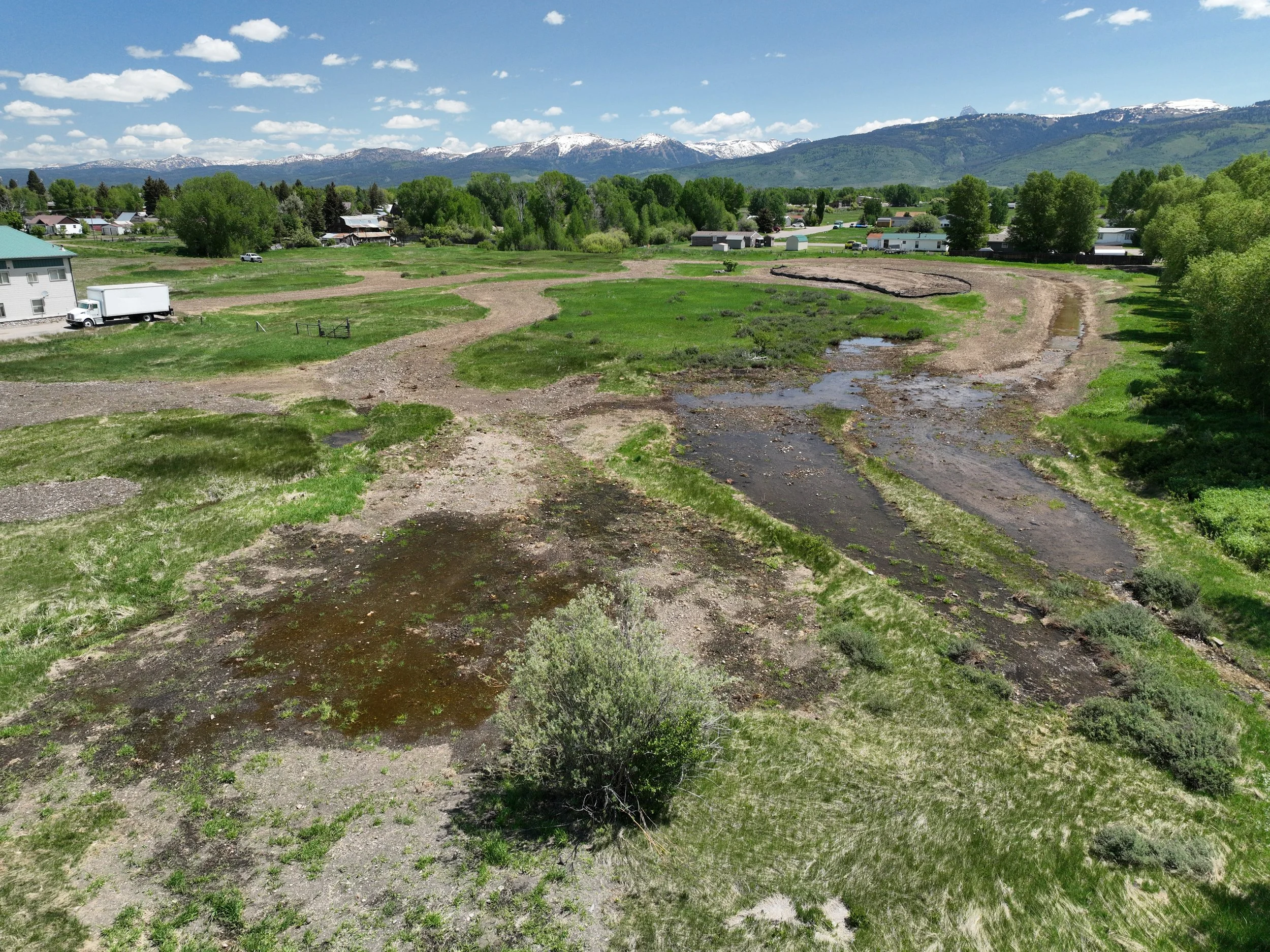
Ditch and Wetland Relocation & Permitting
TYPE - Wetland Delineation, Regulatory Permitting, Mitigation, Wetland Design
GOAL - Develop wetland and ditch relocation plans that consolidate wetlands on property and allow for future commercial development
LOCATION - Driggs, ID
DATE - 2023-2025
CLIENT - Private landowner
SCOPE – Aquatic Resource Inventory/Wetland Delineation, City of Driggs Permitting, Army Corps of Engineers Permitting, Relocation Design

Wildlife utilizing habitat pond immediately following construction (pre-revegetation)
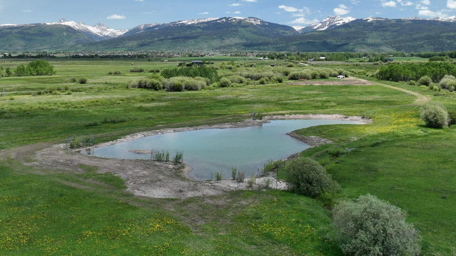
Six months post-construction
T10MTNS Habitat Pond
TYPE – Wetland Delineation, Regulatory Permitting, Mitigation
GOAL – Procure local, state and federal permits for a residential construction project in wetlands near the Teton River, achieved with on-site habitat improvement; Convert degraded upland area to a highly functional habitat pond for waterbirds and wildlife
LOCATION – Victor, ID
DATE – 2024-2025
CLIENT – Private landowner
SCOPE – Aquatic Resource Inventory/Wetland Delineation, Teton County Permitting, Army Corps of Engineers Permitting, Mitigation Design, Construction Oversight, Mitigation Monitoring

Teton River Off-site Compensatory Mitigation
TYPE – Wetland Delineation, Regulatory Permitting, Mitigation
GOAL – Procure local, state and federal permits for a residential construction project in wetlands near the Teton River, achieved with off-site habitat improvement
LOCATION – Victor, ID
DATE – 2024
CLIENT – Private landowner
SCOPE – Aquatic Resource Inventory/Wetland Delineation, Teton County Permitting, Army Corps of Engineers Permitting, Mitigation Design, Construction Oversight, Mitigation Monitoring

Helmick Ranch Baseline Inventory
TYPE – Baseline Inventory
GOAL – Document existing conditions on a 3,500 acre property to meet Idaho Department of Fish & Game requirements for a Conservation Easement
LOCATION – Hill City, ID
DATE – 2024
CLIENT – Idaho Department of Fish & Game
SCOPE – Fieldwork, Baseline Inventory
DETAILS – Utilized drone, historical aerial imagery, vehicle and foot access, agency supplied reports and figures, and interviews with agency representatives and landowners

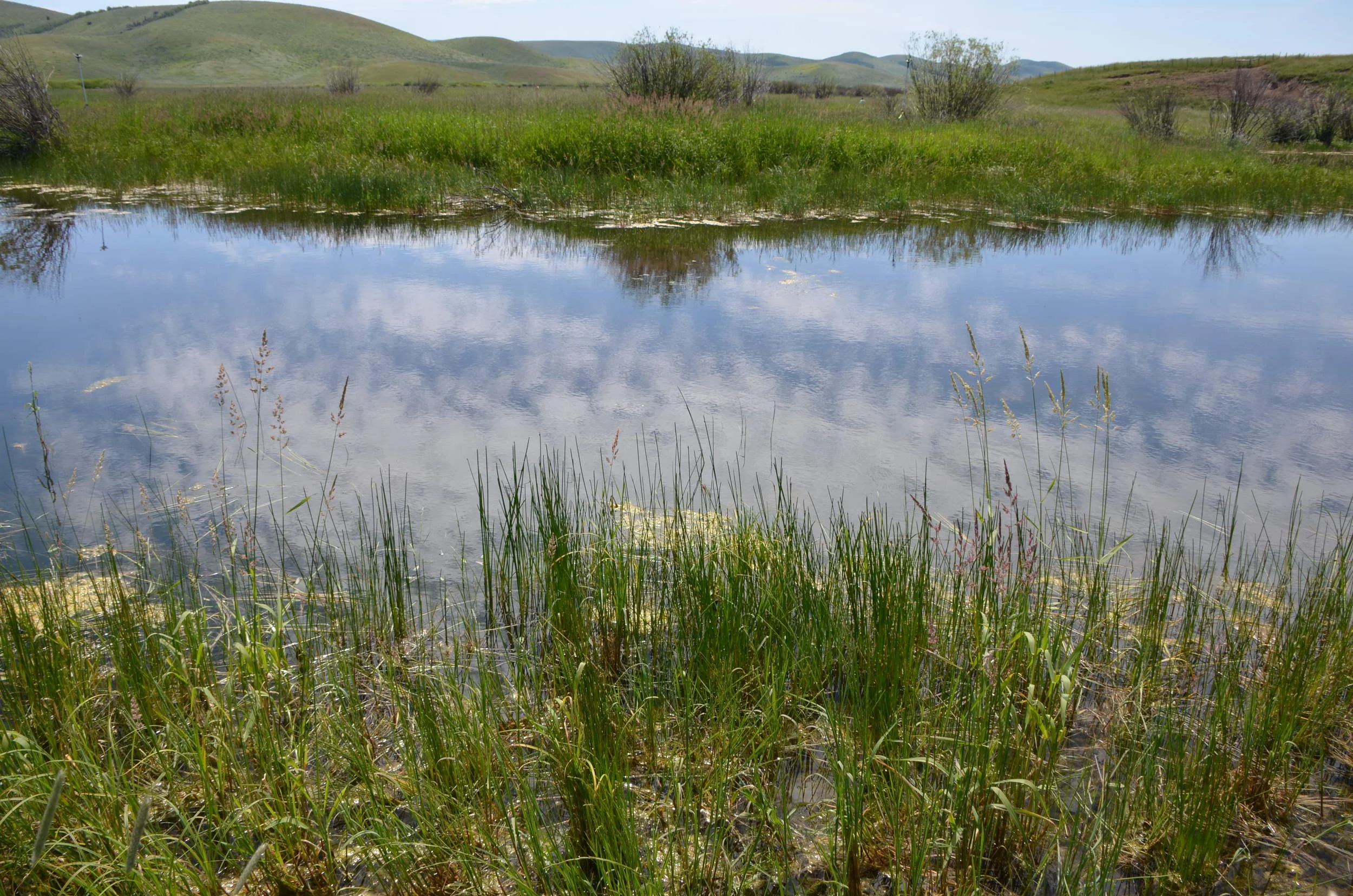
Drone photograph of active spawning
Cutthroat Spawning Habitat Monitoring & Adaptive Management
TYPE – Monitoring & Adaptive Management
GOAL – Increase Snake River Cutthroat spawning in two springs creeks by improving riffle and glide habitat
LOCATION – Wilson, WY
DATE – 2008-present
CLIENT – HOA
SCOPE – Design and implement habitat restoration project, on-going annual monitoring, develop and implement adaptive management strategies to maintain project success

Two Rivers Levee
TYPE – Wetland Delineation, Regulatory Permitting, Mitigation, & Teton County, WY Environmental Analysis
GOAL – Procure local, state and federal permits for a levee improvement project on the Gros Ventre River
LOCATION – Jackson, WY
DATE – 2016 - 2025
CLIENT – Private landowner
SCOPE – Aquatic Resource Inventory/Wetland Delineation, Hydraulic Modeling, HEC-RAS analysis, Teton County Environmental Analysis, Army Corps of Engineers Permitting, Mitigation Plan, Revegetation Oversight, Mitigation Monitoring
Area included in the Wetland Delineation and Environmental Analysis

Karns Meadow Stormwater Treatment Wetland
TYPE - Feasibility analysis and wetland design
GOAL - Remove pollutants from urban stormwater runoff and provide wildlife habitat
LOCATION - Jackson, Wyoming
DATE - 2005-2011
CLIENT - Town of Jackson
SCOPE - Hydrologic and ecological analysis, stakeholder input, treatment wetland engineering and revegetation design, construction oversight

Lower Henry’s Fork Wetland Mitigation Prioritization
TYPE - Wetland mitigation area study
GOAL - Develop a prioritized potential wetland mitigation map for the Lower Henry’s Fork corridor to be used by multiple agencies to identify mitigation sites with the greatest ecological and conservation benefits.
LOCATION - Madison and Fremont County, ID
CLIENT - Henry’s Fork Foundation
SCOPE - Collaborate with government agencies and NGO’s to define project ranking objectives. Gather and analyze GIS data pertaining to: Yellow billed cuckoo habitat, wetlands, land ownership, conservation easements, county zoning, eroding streambanks, river complexity. The project report ranked parcels within the study area and identified 13 parcels that have a high potential for meaningful mitigation.

Stateline Road Improvements – Teton County WY Environmental Analysis
TYPE – Teton County, WY Environmental Analysis
GOAL – Provide Environmental Analysis for proposed road improvements
LOCATION – Alta, WY
DATE – 2018
CLIENT – Teton County, WY Public Works Department
SCOPE – Coordinate with Teton County and engineering firms, field data collection & analysis, compile and submit EA report, incorporate changing development plans, development impact analysis, habitat enhancement plan

Stateline Road Improvements - Wetland Delineation & Permitting
TYPE – Wetland Delineation & Permitting
GOAL – Determine and complete all wetland permitting requirements for proposed road improvements
LOCATION – Alta, WY
DATE – 2018
CLIENT – Teton County, WY Public Works Department
SCOPE – Wetland Delineation / Aquatic Resource Inventory fieldwork and report compilation, coordinate with multiple states and agencies to determine permitting and mitigation needs, field data collection & analysis

Wetland Delineation on Teton River
Bates Boat Ramp – Wetland Delineation, Permitting and Mitigation
TYPE – Wetland Delineations, Regulatory Permitting, Mitigation
GOAL – Determine and complete all permitting and mitigation requirements for proposed boat ramp improvements
LOCATION – Driggs, ID
DATE – 2018
CLIENT – Teton County, Idaho
SCOPE – Coordinate with agencies to determine permitting and mitigation needs, field data collection & analysis, wetland delineation, topographic survey, mitigation design

wetland mitigation project specifications
Wilson Law Corp – Wetland delineation, permitting, and mitigation
GOAL – Determine and complete all permitting and mitigation requirements for proposed driveway improvements
LOCATION – Driggs, ID
DATE – 2018
CLIENT – Private landowner
SCOPE – Coordinate with agencies to determine permitting and mitigation needs, wetland delineation, field data collection & analysis, topographic survey, groundwater monitoring, mitigation design

Corral Creek Ranch – Stock Pond Reclamation
TYPE – Design-Build Services; Regulatory Permitting
GOAL – Reclaim two illegal ponds installed by a previous owner and degraded streams on the ranch to natural functioning channels and pre-existing conditions
LOCATION – Beaverhead County, MT
DATE – 2017
CLIENT – Private landowner
PARTNERS – Montana FWP, US Fish & Wildlife Service, Montana Land Reliance, Humane Society Wildlife Land Trust, The Nature Conservancy
SCOPE – Field data collection & analysis, topographic survey, fish passage analysis, channel restoration, habitat enhancement design, revegetation design, construction management, permitting
Earthwork to restore unpermitted stock pond

environmental analysis layout
Rutter – Teton County WY Environmental Analysis
TYPE – Teton County, WY Environmental Analysis
GOAL – Provide Environmental Analysis for proposed development
LOCATION – Alta, WY
DATE – 2017
CLIENT – Teton County / Private landowner
SCOPE – Coordinate with Teton County, field data collection & analysis, compile and submit EA report, incorporate changing development plans

Crow Creek Wetland Delineation & Mitigation
TYPE – Wetland Delineation, Regulatory Permitting, Mitigation, Design-Build Services
GOAL – Procure an after-the-fact road permit from the U.S. Army Corps of Engineers
LOCATION – Afton, WY
DATE - 2016
CLIENT – Private landowner
SCOPE –Aquatic Resource Inventory/Wetland Delineation, Impact Analysis, Mitigation, Monitoring, Revegetation Design and Installation, Weed Control
Wetland created as mitigation for the wetland impacts from the un-permitted road
Phosphate Mine Wetland Mitigation
TYPE – Wetland Delineation, Regulatory Permitting, Mitigation, Design-Build Services
GOAL – Design, implement and monitor over 4 acres of wetland, 1 mile of eroding streambanks, and 2.8 acres of open water pond to meet mitigation requirements for impacts from a mine project
LOCATION - Soda Springs, ID
DATE – 2016
CLIENT – Monsanto
SCOPE – Bio-engineered Bank Stabilization, Wetland Mitigation, Weed Control, Monitoring, Adaptive Management, Groundwater Monitoring, Field Data Collection, Topographic Survey, Revegetation Design and Implementation
wetland mitigation project performed by Intermountain Aquatics

Stream Alternation Permit Violation Resolution
TYPE – Regulatory Permitting
GOAL – Work with IDWR and ACOE to bring a stream alteration permit back into compliance
LOCATION – Island Park, ID
DATE – 2016
CLIENT – Private landowner
SCOPE – Habitat Inventory & Mapping, Topographic Survey, Channel Restoration, Revegetation Design, Project Monitoring

Alta, Wyoming Environmental Analysis
TYPE – Teton County, WY Environmental Analysis
GOAL – Provide environmental analysis for a lot split and residential home project
LOCATION – Alta, WY
DATE – 2015
CLIENT – Private landowner
SCOPE – Field Inventory, Vegetation Mapping, Wildlife Mapping, Impact Analysis, Environmental Analysis Report, Habitat Mitigation Plan
Preliminary vegetation map for an Environmental Analysis

Un-permitted road built through wetlands
Stream Crossing Violation Resolution
TYPE – Regulatory Permitting, Mitigation
GOAL – Work with IDWR and ACOE to bring a stream crossing project back into compliance
LOCATION – Felt, ID
DATE – 2016
CLIENT – Private landowner
SCOPE – Habitat Inventory & Mapping, Channel Restoration Design, Revegetation Design, Monitoring

Teton County Environmental Analysis
TYPE – Teton County, WY Environmental Analysis
GOAL – Provide environmental analysis for a resort re-location and cell tower project
LOCATION – Jackson, WY
DATE – 2015
CLIENT – Teton County / Snake River Sporting Club
SCOPE – Field Inventory, Vegetation Mapping, Wildlife Mapping, Impact Analysis, Environmental Analysis Report, Habitat Mitigation Plan
Wildlife and vegetation maps for environmental analysis